STOP: MEGA-DAIRIES
LISTEN/DOWNLOAD [MP3]
SB CUE Hwy 223/Bear Mountain Blvd./Arvin - Exit 239
NB CUE Hwy 223/Bear Mountain Blvd. - Exit 239
SITE
Borba Dairy
View LANDSAT Map
LOCATION
The Borba Dairies are located about two miles east of the I-5 on Old River Road between State Route 119 and State Route 223
THREATS AND CONTAMINANTS
Air emissions of ammonia and hydrogen sulfide, volatile organic compounds (VOCs), nitrate contamination of drinking water, NOX, PM, smog, pathogens.
VOICE
Tony Azevedo
Brent Newell, Center on Race, Poverty, and the Environment (CRPE)
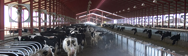
California dairies are the number one milk producers in the nation. As the state's largest agricultural industry they produce $4 billion worth of milk annually (as measured at the farm, not after processing). More than two million cows are spread across 1,500 dairies in the San Joaquin Valley with the majority located in Tulare County, the top milk-producing county in the nation.
Over the past twenty years the dairy industry has transformed from traditionally family-run enterprises with 100 to 300 cows to industrial-sized mega-dairies with thousands of animals. This trend is illustrated in the controversial Borba dairies south of Bakersfield. Each will have 14,000 cows, totaling 28,000 cows in one area. The cumulative environmental consequences of constructing these mega-dairies is staggering considering that the San Joaquin is already burdened with the some of nation's worse air quality and has extensive groundwater contamination. Mega-dairies can emit air pollution in such volume as to be comparable to traditional stack emission sources like refineries and power plants.
An adult cow produces twenty times more organic waste per day than a human. Dairy waste not used for fertilizer applications is stored into large, open-air "lagoons" which emit millions of pounds of ammonia and other smog-forming gases each year, according to the San Joaquin Valley Air Pollution Control District. In August 2005, the district updated the annual VOC emission factor per head of dairy cattle from 12.8 to 19.3 pounds making dairies the largest source of VOCs in the Valley basin. With these new statistics dairies now surpass gas-powered vehicles as the Valley's number one air pollution source.
LISTEN/DOWNLOAD [MP3]
SB CUE Hwy 223/Bear Mountain Blvd./Arvin - Exit 239
NB CUE Hwy 223/Bear Mountain Blvd. - Exit 239
SITE
Borba Dairy
View LANDSAT Map
LOCATION
The Borba Dairies are located about two miles east of the I-5 on Old River Road between State Route 119 and State Route 223
THREATS AND CONTAMINANTS
Air emissions of ammonia and hydrogen sulfide, volatile organic compounds (VOCs), nitrate contamination of drinking water, NOX, PM, smog, pathogens.
VOICE
Tony Azevedo
Brent Newell, Center on Race, Poverty, and the Environment (CRPE)
California dairies are the number one milk producers in the nation. As the state's largest agricultural industry they produce $4 billion worth of milk annually (as measured at the farm, not after processing). More than two million cows are spread across 1,500 dairies in the San Joaquin Valley with the majority located in Tulare County, the top milk-producing county in the nation.
Over the past twenty years the dairy industry has transformed from traditionally family-run enterprises with 100 to 300 cows to industrial-sized mega-dairies with thousands of animals. This trend is illustrated in the controversial Borba dairies south of Bakersfield. Each will have 14,000 cows, totaling 28,000 cows in one area. The cumulative environmental consequences of constructing these mega-dairies is staggering considering that the San Joaquin is already burdened with the some of nation's worse air quality and has extensive groundwater contamination. Mega-dairies can emit air pollution in such volume as to be comparable to traditional stack emission sources like refineries and power plants.
An adult cow produces twenty times more organic waste per day than a human. Dairy waste not used for fertilizer applications is stored into large, open-air "lagoons" which emit millions of pounds of ammonia and other smog-forming gases each year, according to the San Joaquin Valley Air Pollution Control District. In August 2005, the district updated the annual VOC emission factor per head of dairy cattle from 12.8 to 19.3 pounds making dairies the largest source of VOCs in the Valley basin. With these new statistics dairies now surpass gas-powered vehicles as the Valley's number one air pollution source.