STOP: BAYVIEW HUNTERS POINT / SF
LISTEN/DOWNLOAD [MP3]
SB CUE Begin when you get on the Bay Bridge heading eastbound on I-80
NB CUE Begin when you get on the Bay Bridge heading westbound on I-80
SITE
PG & E Power Plant / Hunters Point Naval Shipyard site
View LANDSAT Map
LOCATION
PG&E, 1000 Evans Ave., San Francisco
Hunters Point Naval Shipyard, 322 Innes Ave., San Francisco
THREATS AND CONTAMINANTS
Groundwater, sediment, soil, and surface water contamination with asbestos, fuel, pesticide, heavy metals, PCBs, off-gas from VOCs, radium 226, cesium 137, non-point source pollution, air pollution
VOICE
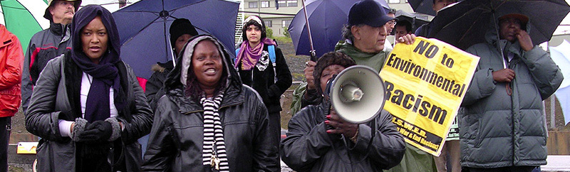
Marie Harrison, Greenaction for Health & Environmental Justice
The Bayview Hunters Point neighborhood is bounded by Cesar Chavez Street to the north, the San Francisco Bay to the east, Highway 101 to the west and the City/County border of San Francisco to the south. The neighborhood is home to one Superfund site, a PG&E power plant, the former Hunters Point Naval Shipyard site, a sewage treatment plant, 100 Brownfield sites, twenty-five underground petroleum storage tanks, and more than a third of the city's 1,263 hazardous waste generators. When operating, PG&E's Hunters Point Power Plant discharges almost 321 tons of pollution into the air each year, including PM10 particles, carbon monoxide, sulfur dioxide, nitrogen dioxide, and volatile organic compounds (VOCs).
The health of local residents has been heavily impacted by the ongoing environmental contamination of the area's air, water, and soil with toxic particulate matter, pesticide residual, petrochemicals, heavy metals, asbestos, and radioactive materials - more than 200 known toxic chemicals and materials according to the Environmental Protection Agency (EPA). Most impacted are the 12,000 residents who live east of Third Street, in proximity to heavy industry, power plants, and truck traffic. Of these households, approximately seventy percent are African American and fifteen percent are of Asian descent.
Asthma is one of the most serious environmental health challenges facing residents of Bayview Hunters Point. Additionally, health surveys show that in Bayview Hunters Point rates of cervical and breast cancer were found to be double the rate found in other parts of the Bay Area. Hospitalization rates for congestive heart failure, hypertension, diabetes, and emphysema were found to be more than three times the statewide average. Bayview Hunters Point and the bordering neighborhood of Potrero Hill, account for more than half of all infant mortality in the San Francisco area.
LISTEN/DOWNLOAD [MP3]
SB CUE Begin when you get on the Bay Bridge heading eastbound on I-80
NB CUE Begin when you get on the Bay Bridge heading westbound on I-80
SITE
PG & E Power Plant / Hunters Point Naval Shipyard site
View LANDSAT Map
LOCATION
PG&E, 1000 Evans Ave., San Francisco
Hunters Point Naval Shipyard, 322 Innes Ave., San Francisco
THREATS AND CONTAMINANTS
Groundwater, sediment, soil, and surface water contamination with asbestos, fuel, pesticide, heavy metals, PCBs, off-gas from VOCs, radium 226, cesium 137, non-point source pollution, air pollution
VOICE
Marie Harrison, Greenaction for Health & Environmental Justice
The Bayview Hunters Point neighborhood is bounded by Cesar Chavez Street to the north, the San Francisco Bay to the east, Highway 101 to the west and the City/County border of San Francisco to the south. The neighborhood is home to one Superfund site, a PG&E power plant, the former Hunters Point Naval Shipyard site, a sewage treatment plant, 100 Brownfield sites, twenty-five underground petroleum storage tanks, and more than a third of the city's 1,263 hazardous waste generators. When operating, PG&E's Hunters Point Power Plant discharges almost 321 tons of pollution into the air each year, including PM10 particles, carbon monoxide, sulfur dioxide, nitrogen dioxide, and volatile organic compounds (VOCs).
The health of local residents has been heavily impacted by the ongoing environmental contamination of the area's air, water, and soil with toxic particulate matter, pesticide residual, petrochemicals, heavy metals, asbestos, and radioactive materials - more than 200 known toxic chemicals and materials according to the Environmental Protection Agency (EPA). Most impacted are the 12,000 residents who live east of Third Street, in proximity to heavy industry, power plants, and truck traffic. Of these households, approximately seventy percent are African American and fifteen percent are of Asian descent.
Asthma is one of the most serious environmental health challenges facing residents of Bayview Hunters Point. Additionally, health surveys show that in Bayview Hunters Point rates of cervical and breast cancer were found to be double the rate found in other parts of the Bay Area. Hospitalization rates for congestive heart failure, hypertension, diabetes, and emphysema were found to be more than three times the statewide average. Bayview Hunters Point and the bordering neighborhood of Potrero Hill, account for more than half of all infant mortality in the San Francisco area.