STOP: KESTERSON NWR
LISTEN/DOWNLOAD [MP3]
SB CUE Gustine/Merced 1mi.
NB CUE 140/Gustine/Merced
SITE
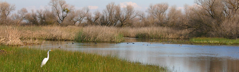
Kesterson National Wildlife Refuge
View LANDSAT Map
LOCATION
Visit the Kesterson National Wildlife Refuge by exiting at 140 East. The refuge is approximately seven miles from the I-5 and a few miles outside of the town of Gustine.
THREATS AND CONTAMINANTS
Catastrophic selenium poisoning from agricultural run-off
VOICE
Gary Zahm, former Kesterson NWR complex manager
Part of the larger San Luis National Wildlife Refuge, the Kesterson National Wildlife Refuge is located eighteen miles north of Los Banos. Established in 1970 as part of a federal U.S. Bureau of Reclamation (BOR) project, the 10,621-acre refuge was designed to aid farmers in transporting agricultural runoff away from West Side farms. By the 1980s Kesterson would become the site of a devastating wildlife selenium poisoning disaster that would make national news.
Proper agricultural drainage is necessary to flush out toxic buildup of salts and other minerals that would otherwise ruin crops. To address this an eighty-two-mile long concrete-lined channel was constructed by the BOR for drainage terminating at the Kesterson Reservoir. Here, twelve evaporation ponds on 1,280 acres were planned for construction to dually serve as run-off retention ponds and wetland habitat for the 12,000 wintering waterfowl that use the area.
The plan seemed a logical solution and some ponds were constructed. By 1981, however, routine field tests administered by San Luis NWR complex manager Gary Zahm and personnel indicated excessive levels of selenium at the reservoir - over 300 times the maximum limit listed by the federal government. Selenium is a naturally occurring trace element found in western desert soils. It is necessary for both human and animal biological functions but can be toxic at high levels. Thousands of dead and deformed birds were discovered throughout the reservoir by 1983 with newborn birds exhibiting grisly deformities. Excessive selenium levels were eventually attributed as the cause. The Department of the Interior was forced to abandon the Kesterson wastewater drainage project by 1988.
Wetlands Side Trip Loop (southbound directions):
From the I-5, take Hwy. 140 east through Gustine. About two and a half miles east of Gustine, look carefully for Santa Fe Grade Road, and turn right, heading south. (Warning: This is a dirt road, and difficult after rain) This will take you through wetlands just southwest of the Kesterson Unit. You will eventually meet up with Hwy. 165 south. Turn right, and follow Hwy. 165 southbound to Hwy. 152. At Hwy. 152, take a right and head west to rejoin I-5.
LISTEN/DOWNLOAD [MP3]
SB CUE Gustine/Merced 1mi.
NB CUE 140/Gustine/Merced
SITE
Kesterson National Wildlife Refuge
View LANDSAT Map
LOCATION
Visit the Kesterson National Wildlife Refuge by exiting at 140 East. The refuge is approximately seven miles from the I-5 and a few miles outside of the town of Gustine.
THREATS AND CONTAMINANTS
Catastrophic selenium poisoning from agricultural run-off
VOICE
Gary Zahm, former Kesterson NWR complex manager
Part of the larger San Luis National Wildlife Refuge, the Kesterson National Wildlife Refuge is located eighteen miles north of Los Banos. Established in 1970 as part of a federal U.S. Bureau of Reclamation (BOR) project, the 10,621-acre refuge was designed to aid farmers in transporting agricultural runoff away from West Side farms. By the 1980s Kesterson would become the site of a devastating wildlife selenium poisoning disaster that would make national news.
Proper agricultural drainage is necessary to flush out toxic buildup of salts and other minerals that would otherwise ruin crops. To address this an eighty-two-mile long concrete-lined channel was constructed by the BOR for drainage terminating at the Kesterson Reservoir. Here, twelve evaporation ponds on 1,280 acres were planned for construction to dually serve as run-off retention ponds and wetland habitat for the 12,000 wintering waterfowl that use the area.
The plan seemed a logical solution and some ponds were constructed. By 1981, however, routine field tests administered by San Luis NWR complex manager Gary Zahm and personnel indicated excessive levels of selenium at the reservoir - over 300 times the maximum limit listed by the federal government. Selenium is a naturally occurring trace element found in western desert soils. It is necessary for both human and animal biological functions but can be toxic at high levels. Thousands of dead and deformed birds were discovered throughout the reservoir by 1983 with newborn birds exhibiting grisly deformities. Excessive selenium levels were eventually attributed as the cause. The Department of the Interior was forced to abandon the Kesterson wastewater drainage project by 1988.
Wetlands Side Trip Loop (southbound directions):
From the I-5, take Hwy. 140 east through Gustine. About two and a half miles east of Gustine, look carefully for Santa Fe Grade Road, and turn right, heading south. (Warning: This is a dirt road, and difficult after rain) This will take you through wetlands just southwest of the Kesterson Unit. You will eventually meet up with Hwy. 165 south. Turn right, and follow Hwy. 165 southbound to Hwy. 152. At Hwy. 152, take a right and head west to rejoin I-5.