STOP: LOS ANGELES RIVER
LISTEN/DOWNLOAD [MP3]
SB CUE Colorado St.
NB CUE Immediately after the Boyle Heights stop finishes.
SITE
Los Angeles River
View LANDSAT Map
LOCATION
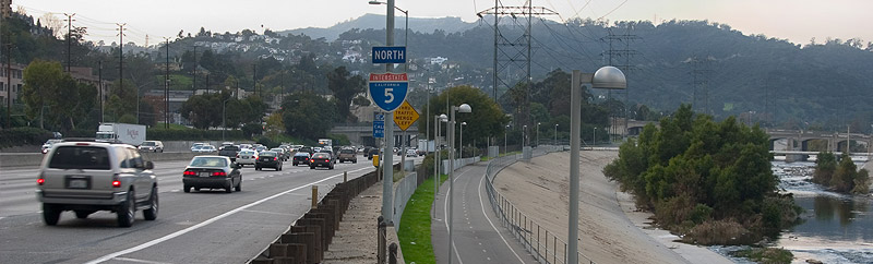
The Glendale Narrows can be viewed directly from the freeway along the Glendale/Los Feliz corridor and can be accessed via foot or by bike at the Guardians of the River Gate on Los Feliz Blvd. just off the I-5.
THREATS AND CONTAMINANTS
Water pollution and habitat destruction
VOICE
Lewis MacAdams, FoLAR co-founder and write
The Friends of the Los Angeles River (FoLAR) was co-founded in 1986 by activist, writer and filmmaker Lewis MacAdams to revitalize and protect the Los Angeles River, one of the most hydraulically modified urban rivers in the world. Nearly seventy-five percent of the fifty-two mile long river is enclosed in concrete. Channelization of the river was initiated in 1938 by U.S. Army Corps of Engineers as part of a massive flood control project, which continued until the late 1950s.
FoLAR has been responsible for cleaning up sections of the river through community-based volunteer activities which include restoration of native habitat, removal of invasive exotic species, monitoring the river's water quality, and controlling toxic pollution from dumping and storm drains. The non-profit organizes educational and community activities including monthly river walks.
Renewed interested in the river initiated in part by FoLAR has spawned numerous "pocket parks" which include pedestrian walkways, bike paths, and wildlife viewing areas. Viewable from the I-5, one of the publicly accessible areas known as the Glendale Narrows shows evidence of the river's former ecology and alludes to its vibrant past. This section of the river is soft-bottomed and lies close to the underlying water table. Because of this the Corps was discouraged from encasing it in cement as they did with the majority the river's channel. Within this riparian corridor foliage and trees push through the channel's floor forming islands of vegetation, which sustain an array of flora and fauna including willow groves, cattails, sycamores and up to 140 species of birds along with a few secluded transient encampments.
LISTEN/DOWNLOAD [MP3]
SB CUE Colorado St.
NB CUE Immediately after the Boyle Heights stop finishes.
SITE
Los Angeles River
View LANDSAT Map
LOCATION
The Glendale Narrows can be viewed directly from the freeway along the Glendale/Los Feliz corridor and can be accessed via foot or by bike at the Guardians of the River Gate on Los Feliz Blvd. just off the I-5.
THREATS AND CONTAMINANTS
Water pollution and habitat destruction
VOICE
Lewis MacAdams, FoLAR co-founder and write
The Friends of the Los Angeles River (FoLAR) was co-founded in 1986 by activist, writer and filmmaker Lewis MacAdams to revitalize and protect the Los Angeles River, one of the most hydraulically modified urban rivers in the world. Nearly seventy-five percent of the fifty-two mile long river is enclosed in concrete. Channelization of the river was initiated in 1938 by U.S. Army Corps of Engineers as part of a massive flood control project, which continued until the late 1950s.
FoLAR has been responsible for cleaning up sections of the river through community-based volunteer activities which include restoration of native habitat, removal of invasive exotic species, monitoring the river's water quality, and controlling toxic pollution from dumping and storm drains. The non-profit organizes educational and community activities including monthly river walks.
Renewed interested in the river initiated in part by FoLAR has spawned numerous "pocket parks" which include pedestrian walkways, bike paths, and wildlife viewing areas. Viewable from the I-5, one of the publicly accessible areas known as the Glendale Narrows shows evidence of the river's former ecology and alludes to its vibrant past. This section of the river is soft-bottomed and lies close to the underlying water table. Because of this the Corps was discouraged from encasing it in cement as they did with the majority the river's channel. Within this riparian corridor foliage and trees push through the channel's floor forming islands of vegetation, which sustain an array of flora and fauna including willow groves, cattails, sycamores and up to 140 species of birds along with a few secluded transient encampments.