STOP: TULARE DRY LAKE
LISTEN/DOWNLOAD [MP3]
SB CUE Jayne Ave.
NB CUE Jayne. Ave/Coalinga-Exit 325
SITE
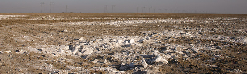
Tulare Dry Lake
View LANDSAT Map
LOCATION
The Tulare Lake Bed lies southeast of the I-5 from Kettleman City. Historically, the lake covered nearly all of Kings County and part of Tulare and Kern Counties
THREATS AND CONTAMINANTS
Native American displacement and extermination, broken treaties, habitat destruction
VOICE
Gerald Haslam, historian/writer
Desertified by the ranchers and farmers who settled here during the nineteenth century, the "phantom" Tulare Lake formed at a broad alluvial fan near the town of Hanford with inflows from the Sierra Nevada's Kings, Kaweah, White and Tule rivers. During the early part of the 19th century Tulare Lake was considered the largest fresh body of water west of the Great Lakes. Named for the "tules," or bulrushes that surrounded the lake, Tulare at its wettest recorded year covered nearly 760 square miles and supported vast populations of deer, elk, antelope, grizzly bear, migratory waterfowl, and aquatic species.
Before Spanish and Anglo-American settlement the Tulare Lake region supported the Yokut, a large semipermanent aboriginal civilization, which consisted of sixteen regional subcultures. The Yokuts were considered one of the highest regional populations in North America with an estimated 18,000 to 50,000 individuals in the early 19th century. By midcentury their numbers had drastically diminished from disease epidemics and forced removal.
Non-native settlement increased throughout the region with completion of the 1853-55 Federal Land Survey. Implementation of the Swamp and Overflowed Lands Act of 1850 consequently sealed the lake's fate as settlers were encouraged to reclaim "unproductive" land by draining wetland habitat, further reducing native flora and fauna dependent of the lake's ecology. Livestock grazing, agriculture practices and the introduction of exotic European grasses significantly altered the original native ecology of the greater region. Today for the most part dry, the basin will on occasion metamorphose into a small, intermittent lake yielding a fleeting glimpse of its former self.
"After the bloodshed is done we come back to the lake of our fathers. But there is no longer food as there was in the beginning. The antelope and deer are frightened away and the herds no longer come to our waters. We dare not hunt to far, lest the stockman think we are thieving. The fish are caught with hooks and carried away in barrels, not swimming into our willow traps as we need them. The White men trample our blackberry patches, not caring if the stems that bear fruit are broken. The ducks fly from the guns and though they come to our traps they are fewer. Another year with no acorns, our people are too lean to hunt, and the children are starving."
Indian Harry quoted from "The First Blade," by May Merril Miller, 1938.
LISTEN/DOWNLOAD [MP3]
SB CUE Jayne Ave.
NB CUE Jayne. Ave/Coalinga-Exit 325
SITE
Tulare Dry Lake
View LANDSAT Map
LOCATION
The Tulare Lake Bed lies southeast of the I-5 from Kettleman City. Historically, the lake covered nearly all of Kings County and part of Tulare and Kern Counties
THREATS AND CONTAMINANTS
Native American displacement and extermination, broken treaties, habitat destruction
VOICE
Gerald Haslam, historian/writer
Desertified by the ranchers and farmers who settled here during the nineteenth century, the "phantom" Tulare Lake formed at a broad alluvial fan near the town of Hanford with inflows from the Sierra Nevada's Kings, Kaweah, White and Tule rivers. During the early part of the 19th century Tulare Lake was considered the largest fresh body of water west of the Great Lakes. Named for the "tules," or bulrushes that surrounded the lake, Tulare at its wettest recorded year covered nearly 760 square miles and supported vast populations of deer, elk, antelope, grizzly bear, migratory waterfowl, and aquatic species.
Before Spanish and Anglo-American settlement the Tulare Lake region supported the Yokut, a large semipermanent aboriginal civilization, which consisted of sixteen regional subcultures. The Yokuts were considered one of the highest regional populations in North America with an estimated 18,000 to 50,000 individuals in the early 19th century. By midcentury their numbers had drastically diminished from disease epidemics and forced removal.
Non-native settlement increased throughout the region with completion of the 1853-55 Federal Land Survey. Implementation of the Swamp and Overflowed Lands Act of 1850 consequently sealed the lake's fate as settlers were encouraged to reclaim "unproductive" land by draining wetland habitat, further reducing native flora and fauna dependent of the lake's ecology. Livestock grazing, agriculture practices and the introduction of exotic European grasses significantly altered the original native ecology of the greater region. Today for the most part dry, the basin will on occasion metamorphose into a small, intermittent lake yielding a fleeting glimpse of its former self.
"After the bloodshed is done we come back to the lake of our fathers. But there is no longer food as there was in the beginning. The antelope and deer are frightened away and the herds no longer come to our waters. We dare not hunt to far, lest the stockman think we are thieving. The fish are caught with hooks and carried away in barrels, not swimming into our willow traps as we need them. The White men trample our blackberry patches, not caring if the stems that bear fruit are broken. The ducks fly from the guns and though they come to our traps they are fewer. Another year with no acorns, our people are too lean to hunt, and the children are starving."
Indian Harry quoted from "The First Blade," by May Merril Miller, 1938.