STOP: FRESNO-COALINGA RD.
LISTEN/DOWNLOAD [MP3]
SB CUE 33 South - Coalinga Junction 1mi
NB CUEFresno-Coalinga Rd.
SITE
Harris Feeding Company
View LANDSAT Map
LOCATION
Fresno-Coalinga Road at I-5
THREATS AND CONTAMINANTS
Methane, ammonia, carbon dioxide, nitrous oxide, pathogens
VOICE
Dr. David Igler, Department of History at UC Irvine, Richard Walker, Professor of Geography, UC Berkeley
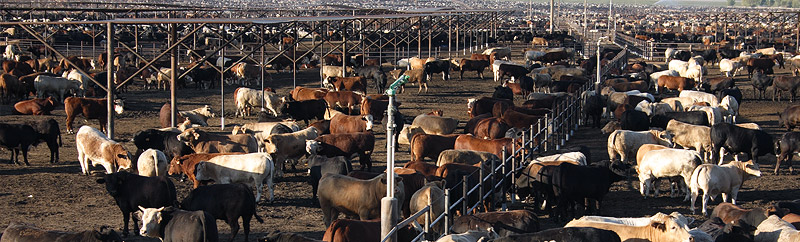
Located near Coalinga, the Harris Ranch conglomerate includes the Harris Feeding Company, Harris Ranch Beef Company, Harris Farms, a hotel with two restaurants, a thoroughbred horse division and an airport. The 800-acre Harris Ranch feedlot is located east of the I-5 on the Fresno-Coalinga Road. The feedlot can process up to 250,000 head cattle annually. At any given time, seventy to 100 thousand head of cattle are present at the lot. Cattle typically spend twelve to sixteen months grazing before arriving at the feedlot at 650 to 750 pounds. Once there, the cows spend three to four months fattening up to an additional 400 pounds before they are slaughtered at Harris Ranch's Selma plant.
Now the largest cattle feeder on the West Coast, Harris Ranch produces nearly 200 million pounds of beef a year but is still considered a moderately sized operation. The nation's largest operations located in the Midwest and Texas feed can feed over 400,000 head of cattle at one time. Mega-feedlot operations such as these pose significant human and environmental health threats including surface and groundwater contamination and air pollution including emission of greenhouse gases.
Through a process called rumination, cows generate methane gas as a digestive by-product. Globally, ruminant livestock produce about eighty million metric tons of methane annually, accounting for about twenty-eight percent of global methane emissions from human-related activities. In the U.S., cattle emit about 5.5 million metric tons of methane per year into the atmosphere, accounting for nineteen percent of global human-related methane emissions. After carbon dioxide (also produced by livestock), methane is the second most significant greenhouse gas contributing to global warming. Although methane breaks down within the atmosphere in ten years it has the potential to trap twenty percent more heat than carbon dioxide.
LISTEN/DOWNLOAD [MP3]
SB CUE 33 South - Coalinga Junction 1mi
NB CUEFresno-Coalinga Rd.
SITE
Harris Feeding Company
View LANDSAT Map
LOCATION
Fresno-Coalinga Road at I-5
THREATS AND CONTAMINANTS
Methane, ammonia, carbon dioxide, nitrous oxide, pathogens
VOICE
Dr. David Igler, Department of History at UC Irvine, Richard Walker, Professor of Geography, UC Berkeley
Located near Coalinga, the Harris Ranch conglomerate includes the Harris Feeding Company, Harris Ranch Beef Company, Harris Farms, a hotel with two restaurants, a thoroughbred horse division and an airport. The 800-acre Harris Ranch feedlot is located east of the I-5 on the Fresno-Coalinga Road. The feedlot can process up to 250,000 head cattle annually. At any given time, seventy to 100 thousand head of cattle are present at the lot. Cattle typically spend twelve to sixteen months grazing before arriving at the feedlot at 650 to 750 pounds. Once there, the cows spend three to four months fattening up to an additional 400 pounds before they are slaughtered at Harris Ranch's Selma plant.
Now the largest cattle feeder on the West Coast, Harris Ranch produces nearly 200 million pounds of beef a year but is still considered a moderately sized operation. The nation's largest operations located in the Midwest and Texas feed can feed over 400,000 head of cattle at one time. Mega-feedlot operations such as these pose significant human and environmental health threats including surface and groundwater contamination and air pollution including emission of greenhouse gases.
Through a process called rumination, cows generate methane gas as a digestive by-product. Globally, ruminant livestock produce about eighty million metric tons of methane annually, accounting for about twenty-eight percent of global methane emissions from human-related activities. In the U.S., cattle emit about 5.5 million metric tons of methane per year into the atmosphere, accounting for nineteen percent of global human-related methane emissions. After carbon dioxide (also produced by livestock), methane is the second most significant greenhouse gas contributing to global warming. Although methane breaks down within the atmosphere in ten years it has the potential to trap twenty percent more heat than carbon dioxide.