DIRECTIONS
Southbound | Northbound
HOW TO DRIVE INVISIBLE-5
Invisible-5 is designed for listening while driving the I-5 between San Francisco and Los Angeles. The simplest way to know when to start tracks is to use road signs along the route as visual cues.
The majority of the audio stops are tied to very little visual information and some stops, such as Tule Fog, are inherently site-shifting and unfixed. The stops are meant however, to give you a specific sense of locale wherever possible.
The spacing of stops is highly irregular due to the physical spacing of the actual sites. There are lengthy (up to 50 minute) gaps between some stops and some are clustered together.
VISUAL TRACK CUEING
We have created sets of Northbound (NB) and Southbound (SB) cues based on exit and mileage road sign names. These signage cues work well in the daytime, but are difficult to follow at night. The stops can also be listened to as a non-cued, unbroken whole.
Depending on your driving speed, a few stops may run over each other slightly around Alpaugh, the south end of the San Joaquin Valley, and Los Angeles.
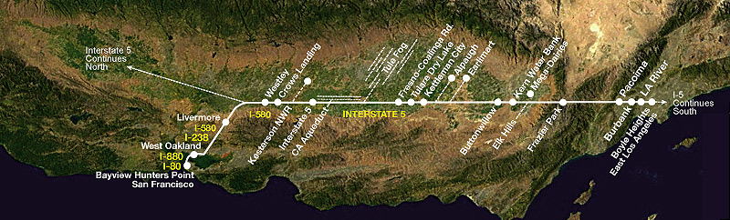
DOWNLOADABLE MAP, DIRECTIONS, AND CUES
The one-page downloadable map shows the general clustering of the sites, and shows the audio stops. It also contains a list of the northbound and southbound cues. If you're interested in a more in-depth map to accompany your trip, we highly recommend the Benchmark Maps California Road & Recreation Atlas
DOWNLOAD MAP, DIRECTIONS AND CUES [PDF]
LOOPS
There are two side trip loops off of the I-5, through Elk Hills and Kesterson National Wildlife Refuge. Directions are listed with the related stop.
-----------------------------------------------------------------------------------------
DIRECTIONS & CUES: SOUTHBOUND
From San Francisco, head east on I-80 (Sign: 80/BayBridge/Oakland) over the Bay Bridge toward Oakland. Just after you exit the bridge, get in the right-hand lane. Take the I-880 southbound ramp (Sign: south 880/Alameda/San Jose) and head southbound on I-880 until you reach the exit for I-238/I-580 east (Sign: Stockton/Fresno). Take the I-238/580 ramp and continue on I-580 to the south I-5/Fresno/Los Angeles exit, just after Altamont Pass. From there, stay on I-5 to Los Angeles. Invisible-5 ends after the Boyle Heights stop concludes.
Bayview Hunters Point - San Francisco
Start: Begin as you get on the Bay Bridge heading eastbound on I-80
West Oakland
SB Cue: As you merge on to the South 880 ramp
Livermore
SB Cue: North Livermore Ave./Downtown Livermore exit
Westley
SB Cue: "Westley 4 /Los Angeles 311" mileage sign
Crows Landing
SB Cue: Crows Landing 4 mi.
Kesterson National Wildlife Refuge
SB Cue: Gustine/Merced 1mi.
Interstate-5
SB Cue: Hwy 152/Monterey/Los Banos-Jct. 1 mi.
California Aqueduct
SB Cue: When you see the Dos Amigos Pumping Station to the east of I-5.
Tule Fog
SB Cue: Panoche Ave.
Fresno-Coalinga Rd.
SB Cue: 33 South-Coalinga Junction 1mi.
Tulare Dry Lake
SB Cue: Jayne Ave.
Kettleman City
SB Cue: Kettleman City 1mi.
Alpaugh
SB Cue: Utica Ave.
Earlimart
SB Cue: Twisselman Rd.
Buttonwillow
SB Cue: Buttonwillow-McKittrick
Kern Water Bank
SB Cue: Hwy 119
/Mega-Dairies
SB Cue:Hwy 223/Bear Mountain Blvd./Arvin
Elk Hills
SB Cue: Hwy 166/Mettler/Maricopa
Frazier Park
SB Cue: Frazier Mountain Park Rd.
Pacoima
SB Cue: Where I-5 and I-405 diverge
Burbank
SB Cue: Where I-5 and CA-170 diverge
LA River
SB Cue: Colorado St.
Boyle Heights - East LA
SB Cue: After you cross Hwy 10
END
Exit anytime after you've finished listening to Boyle Heights.
-----------------------------------------------------------------------------------------
DIRECTIONS & CUES: NORTHBOUND
From Los Angeles, enter I-5 northbound from any ramp south of the Soto Street exit in Boyle Heights. Stay on I-5 through much of the San Joaquin Valley until just north of Westley. Where the I-5 and the I-580 diverge, take I-580 west towards San Francisco (Sign: 580/Tracy/San Francisco only). Follow I-580 to the I-238 connector (Sign: 238 to 880 exit only). Follow the connector and merge onto I-880 north towards Oakland (Sign: 880 north/Oakland). Follow the I-880 (Sign: 880/80/San Francisco/Berkeley) to I-80, towards the Bay Bridge Toll Plaza and San Francisco (Sign: West/San Francisco/Bay Bridge). Invisible-5 northbound concludes with the Bayview Hunters Point stop.
Boyle Heights - East LA
NB Cue: Soto St.
LA River
NB Cue: Immediately after the Boyle Heights stop finishes
Burbank
NB Cue: Olive St.
Pacoima
NB Cue: Immediately after you finish Burbank, or at Van Nuys Blvd.
Frazier Park
NB Cue: Lockwood Valley/Frazier Park-Exit 207
Elk Hills
NB Cue: Hwy 166/Maricopa/Taft - Exit 225
Mega-Dairies
NB Cue: Hwy 223/Bear Mountain Blvd.-Exit 239
Kern Water Bank
NB Cue: Hwy 119
Buttonwillow
NB Cue: 58/Buttonwillow/McKittrick
Earlimart
NB Cue: Twisselman Rd.
Alpaugh
NB Cue: Utica Ave.
Kettleman Cit
NB Cue: Kettleman City/Fresno/41
Tulare Dry Lake
NB Cue: Jayne Ave/Coalinga -Exit 325
Fresno-Coalinga Rd.
NB Cue: Hwy 145/Kerman/Fresno-Coalinga Rd. or 33-South/Fresno/Coalinga Rd/145/Kerman
Tule Fog
NB Cue: Panoche Ave.
California Aqueduct
NB Cue: Nees Ave. or Dos Amigos Pumping Station Vista Point
Interstate 5
NB Cue: Hwy 152/33 South/Los Banos/San Jose
Kesterson National Wildlife Refuge
NB Cue: 140/Gustine/Merced
Crows Landing
NB Cue: Crows Landing Exit 1 mi.
Westley
NB Cue: Westley Exit 1 mi.
Livermore
NB Cue: North Greenville Rd./Laughlin Rd. 1mi.
Follow the 238 connector to the 880 north (238 to 880 exit only) from the two left lanes. Follow the 238 connector (880 North/Oakland) towards Oakland.
West Oakland
NB Cue: Hegenberger Rd./Coliseum Exit
Bayview Hunters Point - San Francisco/
NB Cue: Start: Begin as you get on the Bay Bridge heading westbound on I-80
END
Exit anytime after you've finished listening to Bayview Hunters Point - SF
Southbound | Northbound
HOW TO DRIVE INVISIBLE-5
Invisible-5 is designed for listening while driving the I-5 between San Francisco and Los Angeles. The simplest way to know when to start tracks is to use road signs along the route as visual cues.
The majority of the audio stops are tied to very little visual information and some stops, such as Tule Fog, are inherently site-shifting and unfixed. The stops are meant however, to give you a specific sense of locale wherever possible.
The spacing of stops is highly irregular due to the physical spacing of the actual sites. There are lengthy (up to 50 minute) gaps between some stops and some are clustered together.
VISUAL TRACK CUEING
We have created sets of Northbound (NB) and Southbound (SB) cues based on exit and mileage road sign names. These signage cues work well in the daytime, but are difficult to follow at night. The stops can also be listened to as a non-cued, unbroken whole.
Depending on your driving speed, a few stops may run over each other slightly around Alpaugh, the south end of the San Joaquin Valley, and Los Angeles.
DOWNLOADABLE MAP, DIRECTIONS, AND CUES
The one-page downloadable map shows the general clustering of the sites, and shows the audio stops. It also contains a list of the northbound and southbound cues. If you're interested in a more in-depth map to accompany your trip, we highly recommend the Benchmark Maps California Road & Recreation Atlas
DOWNLOAD MAP, DIRECTIONS AND CUES [PDF]
LOOPS
There are two side trip loops off of the I-5, through Elk Hills and Kesterson National Wildlife Refuge. Directions are listed with the related stop.
-----------------------------------------------------------------------------------------
DIRECTIONS & CUES: SOUTHBOUND
From San Francisco, head east on I-80 (Sign: 80/BayBridge/Oakland) over the Bay Bridge toward Oakland. Just after you exit the bridge, get in the right-hand lane. Take the I-880 southbound ramp (Sign: south 880/Alameda/San Jose) and head southbound on I-880 until you reach the exit for I-238/I-580 east (Sign: Stockton/Fresno). Take the I-238/580 ramp and continue on I-580 to the south I-5/Fresno/Los Angeles exit, just after Altamont Pass. From there, stay on I-5 to Los Angeles. Invisible-5 ends after the Boyle Heights stop concludes.
Bayview Hunters Point - San Francisco
Start: Begin as you get on the Bay Bridge heading eastbound on I-80
West Oakland
SB Cue: As you merge on to the South 880 ramp
Livermore
SB Cue: North Livermore Ave./Downtown Livermore exit
Westley
SB Cue: "Westley 4 /Los Angeles 311" mileage sign
Crows Landing
SB Cue: Crows Landing 4 mi.
Kesterson National Wildlife Refuge
SB Cue: Gustine/Merced 1mi.
Interstate-5
SB Cue: Hwy 152/Monterey/Los Banos-Jct. 1 mi.
California Aqueduct
SB Cue: When you see the Dos Amigos Pumping Station to the east of I-5.
Tule Fog
SB Cue: Panoche Ave.
Fresno-Coalinga Rd.
SB Cue: 33 South-Coalinga Junction 1mi.
Tulare Dry Lake
SB Cue: Jayne Ave.
Kettleman City
SB Cue: Kettleman City 1mi.
Alpaugh
SB Cue: Utica Ave.
Earlimart
SB Cue: Twisselman Rd.
Buttonwillow
SB Cue: Buttonwillow-McKittrick
Kern Water Bank
SB Cue: Hwy 119
/Mega-Dairies
SB Cue:Hwy 223/Bear Mountain Blvd./Arvin
Elk Hills
SB Cue: Hwy 166/Mettler/Maricopa
Frazier Park
SB Cue: Frazier Mountain Park Rd.
Pacoima
SB Cue: Where I-5 and I-405 diverge
Burbank
SB Cue: Where I-5 and CA-170 diverge
LA River
SB Cue: Colorado St.
Boyle Heights - East LA
SB Cue: After you cross Hwy 10
END
Exit anytime after you've finished listening to Boyle Heights.
-----------------------------------------------------------------------------------------
DIRECTIONS & CUES: NORTHBOUND
From Los Angeles, enter I-5 northbound from any ramp south of the Soto Street exit in Boyle Heights. Stay on I-5 through much of the San Joaquin Valley until just north of Westley. Where the I-5 and the I-580 diverge, take I-580 west towards San Francisco (Sign: 580/Tracy/San Francisco only). Follow I-580 to the I-238 connector (Sign: 238 to 880 exit only). Follow the connector and merge onto I-880 north towards Oakland (Sign: 880 north/Oakland). Follow the I-880 (Sign: 880/80/San Francisco/Berkeley) to I-80, towards the Bay Bridge Toll Plaza and San Francisco (Sign: West/San Francisco/Bay Bridge). Invisible-5 northbound concludes with the Bayview Hunters Point stop.
Boyle Heights - East LA
NB Cue: Soto St.
LA River
NB Cue: Immediately after the Boyle Heights stop finishes
Burbank
NB Cue: Olive St.
Pacoima
NB Cue: Immediately after you finish Burbank, or at Van Nuys Blvd.
Frazier Park
NB Cue: Lockwood Valley/Frazier Park-Exit 207
Elk Hills
NB Cue: Hwy 166/Maricopa/Taft - Exit 225
Mega-Dairies
NB Cue: Hwy 223/Bear Mountain Blvd.-Exit 239
Kern Water Bank
NB Cue: Hwy 119
Buttonwillow
NB Cue: 58/Buttonwillow/McKittrick
Earlimart
NB Cue: Twisselman Rd.
Alpaugh
NB Cue: Utica Ave.
Kettleman Cit
NB Cue: Kettleman City/Fresno/41
Tulare Dry Lake
NB Cue: Jayne Ave/Coalinga -Exit 325
Fresno-Coalinga Rd.
NB Cue: Hwy 145/Kerman/Fresno-Coalinga Rd. or 33-South/Fresno/Coalinga Rd/145/Kerman
Tule Fog
NB Cue: Panoche Ave.
California Aqueduct
NB Cue: Nees Ave. or Dos Amigos Pumping Station Vista Point
Interstate 5
NB Cue: Hwy 152/33 South/Los Banos/San Jose
Kesterson National Wildlife Refuge
NB Cue: 140/Gustine/Merced
Crows Landing
NB Cue: Crows Landing Exit 1 mi.
Westley
NB Cue: Westley Exit 1 mi.
Livermore
NB Cue: North Greenville Rd./Laughlin Rd. 1mi.
Follow the 238 connector to the 880 north (238 to 880 exit only) from the two left lanes. Follow the 238 connector (880 North/Oakland) towards Oakland.
West Oakland
NB Cue: Hegenberger Rd./Coliseum Exit
Bayview Hunters Point - San Francisco/
NB Cue: Start: Begin as you get on the Bay Bridge heading westbound on I-80
END
Exit anytime after you've finished listening to Bayview Hunters Point - SF