STOP: ELK HILLS
LISTEN/DOWNLOAD [MP3]
SB CUE Hwy 166/Mettler/Maricopa
NB CUE Hwy 166/Maricopa/Taft - Exit 225
SITE
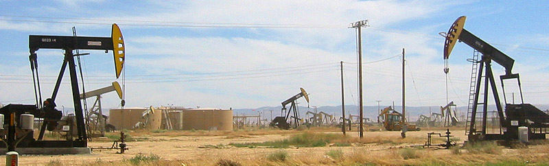
"Super giant" oilfields
View LANDSAT Map
LOCATION
The hills west of I-5 between Hwy. 119 and Hwy. 58
THREATS AND CONTAMINANTS
Air, water and soil contamination, broken treaties
VOICE
Gerald Haslam, writer and historian
Land and resource giveaways by the government to big business have shaped the geopolitical, economic, and environmental landscape of the Elk Hills area, which has been drilled for oil and gas since the late 19th century.
While the Bakersfield region is often associated with oil production, major oilfields are also located on the west side of the I-5 in Kern County between the communities of Lost Hills in the north and Maricopa to the south. Included in this area are three "super giant" oilfields (an oilfield must produce over one billion barrels of oil to qualify); the Midway Sunset Oilfield near Taft (the largest oilfield in the lower forty-eight states); the Elk Hills Oilfield (formally the Elk Hills Naval Petroleum Reserve No.1) north of Highway 119; and the South Belridge Oilfield north of McKittrick. At present, Kern County produces more than 500,000 barrels of oil per day accounting for approximately ten percent of total U.S oil production and one percent of global production.
Much of the oil found in Kern County is "heavy crude" and is best retrieved by injecting steam into the ground to force oil to the surface. Chemical and waste byproducts produced throughout the various stages of oil and gas production contaminate air, water, and soil. The towns of Taft, Maricopa, McKittrick, and Tupman are located within or in close proximity to oil drilling and refinery activity.
Once occupied by the Kitanemuk for thousands of years, the 47,000-acre Elk Hills oilfield is now privately owned by Occidental Petroleum (Oxy), a company known for its poor environmental and human rights record. The sale in 1997, under the guidance of then Vice President Al Gore was the largest privatization of Federal land in U.S. history. The Gore family is a significant stockholder in the company. Tribal members have been fighting Oxy to curtail destruction of and regain access to their ancestral lands to no avail.
Elk Hills Loop (Southbound directions): Take Hwy. 58 west through Buttonwillow. Head south on Hwy. 33 at McKittrick, which will take you past Elk Hills, and through Taft. Just south of Taft, turn left on to Hwy.119 and head northeast until you rejoin the I-5.
LISTEN/DOWNLOAD [MP3]
SB CUE Hwy 166/Mettler/Maricopa
NB CUE Hwy 166/Maricopa/Taft - Exit 225
SITE
"Super giant" oilfields
View LANDSAT Map
LOCATION
The hills west of I-5 between Hwy. 119 and Hwy. 58
THREATS AND CONTAMINANTS
Air, water and soil contamination, broken treaties
VOICE
Gerald Haslam, writer and historian
Land and resource giveaways by the government to big business have shaped the geopolitical, economic, and environmental landscape of the Elk Hills area, which has been drilled for oil and gas since the late 19th century.
While the Bakersfield region is often associated with oil production, major oilfields are also located on the west side of the I-5 in Kern County between the communities of Lost Hills in the north and Maricopa to the south. Included in this area are three "super giant" oilfields (an oilfield must produce over one billion barrels of oil to qualify); the Midway Sunset Oilfield near Taft (the largest oilfield in the lower forty-eight states); the Elk Hills Oilfield (formally the Elk Hills Naval Petroleum Reserve No.1) north of Highway 119; and the South Belridge Oilfield north of McKittrick. At present, Kern County produces more than 500,000 barrels of oil per day accounting for approximately ten percent of total U.S oil production and one percent of global production.
Much of the oil found in Kern County is "heavy crude" and is best retrieved by injecting steam into the ground to force oil to the surface. Chemical and waste byproducts produced throughout the various stages of oil and gas production contaminate air, water, and soil. The towns of Taft, Maricopa, McKittrick, and Tupman are located within or in close proximity to oil drilling and refinery activity.
Once occupied by the Kitanemuk for thousands of years, the 47,000-acre Elk Hills oilfield is now privately owned by Occidental Petroleum (Oxy), a company known for its poor environmental and human rights record. The sale in 1997, under the guidance of then Vice President Al Gore was the largest privatization of Federal land in U.S. history. The Gore family is a significant stockholder in the company. Tribal members have been fighting Oxy to curtail destruction of and regain access to their ancestral lands to no avail.
Elk Hills Loop (Southbound directions): Take Hwy. 58 west through Buttonwillow. Head south on Hwy. 33 at McKittrick, which will take you past Elk Hills, and through Taft. Just south of Taft, turn left on to Hwy.119 and head northeast until you rejoin the I-5.